
Fil:Pan-European corridors.svg

Størrelse for denne PNG-forhåndsvisningen av denne SVG-filen: 392 × 486 piksler Andre oppløsninger: 193 × 240 piksler | 387 × 480 piksler | 619 × 768 piksler | 826 × 1 024 piksler | 1 652 × 2 048 piksler.
Opprinnelig fil (SVG-fil, standardstørrelse 392 × 486 piksler, filstørrelse: 561 KB)
| Denne filen er fra Wikimedia Commons og kan brukes av andre prosjekter. Informasjonen fra filbeskrivelsessiden vises nedenfor. |
Beskrivelse
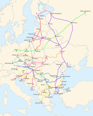
| Beskrivelse |
English: Map of the ten Pan-European transport corridors. |
| Dato | (UTC) |
| Kilde | |
| Opphavsperson |
|
| Andre versjoner |
|
| SVG utvikling | Denne vektorgrafikken ble laget med Inkscape. |


Lisensiering
Denne filen er lisensiert under lisensen Creative Commons Navngivelse-DelPåSammeVilkår 3.0 Unported
- Du står fritt:
- til å dele – til å kopiere, distribuere og overføre verket
- til å blande – til å endre verket
- Under de følgende betingelsene:
- navngivelse – Du må kreditere verket på passende vis, lenke til lisensen og indikere hvorvidt det har blitt gjort endringer. Du kan gjøre det på enhver rimelig måte, men ikke på en måte som antyder at lisensgiveren støtter deg eller din bruk av verket.
- del på samme vilkår – Dersom du remikser, omarbeider eller på annen måte bygger på dette verket, må du kun distribuere resultatet under den samme eller en samsvarende lisens som denne.
Orginal opplastningslogg
This image is a derivative work of the following images:
- File:Blank_map_of_Europe_-_Atelier_graphique_colors.svg licensed with Cc-by-sa-2.5,2.0,1.0, Cc-by-sa-2.5,2.0,1.0/en, GFDL, GFDL/en
- 2008-09-23T18:46:08Z Antigoni 841x731 (498781 Bytes) Montenegro update
- 2007-09-16T15:08:27Z Historicair 841x731 (495651 Bytes)
- 2007-09-13T16:36:42Z Historicair 841x731 (495370 Bytes) {{Information |Description={{fr|Carte vierge de l'Europe, couleurs Atelier Graphique}} {{en|Blank map of Europe with Atelier graphique colors}} |Source=[[:Image:Europe countries.svg]] by [[User:Tintazul|Tintazul]] |Date=13/09
- File:Paneuropetransport.png licensed with PD-self, PD-self/en
- 2007-10-18T08:05:36Z Hoshie 773x942 (45202 Bytes) added Montenegro. Under same lic. as before.
- 2006-12-12T23:11:56Z Albinfo 773x942 (37476 Bytes) Fixed several errors and updated corrections in the original file - sorry for all the misleadings
- 2006-12-05T20:06:34Z Geo-Loge 773x941 (33896 Bytes) Ostrava => Brno, Ostrava added, Wroclaw and Krakow added
- 2006-06-24T17:12:35Z Joy 773x941 (28882 Bytes) Fixed confusion between Lviv and Uzhorod.
- 2005-12-30T22:42:00Z Albinfo 773x941 (37167 Bytes) The ten Pan-European transport corridors. Created by [[User:Albinfo]] using [[User:wiki-vr]]'s [[:Image:Europe_blank_map.png|blank map]].
Uploaded with derivativeFX
Filhistorikk
Klikk på et tidspunkt for å vise filen slik den var på det tidspunktet.
| Dato/klokkeslett | Miniatyrbilde | Dimensjoner | Bruker | Kommentar | |
|---|---|---|---|---|---|
| nåværende | 25. feb. 2018 kl. 23:16 | | 392 × 486 (561 KB) | Nameless23 | Fixed the spelling of Kaliningrad and Nizhny Novgorod. |
| 4. nov. 2009 kl. 01:55 |  | 392 × 486 (561 KB) | Joy | {{Information |Description={{en|Map of the ten Pan-European transport corridors.}} |Source=*File:Pan-European_corridors.svg |Date=2009-11-03 23:54 (UTC) |Author=*File:Pan-European_corridors.svg: *[[:File:Blank_map_of_Europe_-_Atelier_graphique | |
| 4. feb. 2009 kl. 01:46 |  | 392 × 486 (554 KB) | Honza.havlicek | {{Information |Description={{en|Map of the ten Pan-European transport corridors.}} |Source=*File:Blank_map_of_Europe_-_Atelier_graphique_colors.svg *File:Paneuropetransport.png |Date=2009-02-03 23:39 (UTC) |Author=*[[:File:Blank_map_of_Europe_ |
Filbruk
Den følgende siden bruker denne filen:
Global filbruk
Følgende andre wikier bruker denne filen:
- Bruk i ar.wikipedia.org
- Bruk i bg.wikipedia.org
- Bruk i bs.wikipedia.org
- Bruk i en.wikipedia.org
- Bruk i fr.wikipedia.org
- Bruk i he.wikipedia.org
- Bruk i hr.wikipedia.org
- Bruk i hu.wikipedia.org
- Bruk i id.wikipedia.org
- Bruk i it.wikipedia.org
- Bruk i ja.wikipedia.org
- Bruk i ko.wikipedia.org
- Bruk i nl.wikipedia.org
- Bruk i pl.wikipedia.org
- Bruk i ro.wikipedia.org
- Bruk i ru.wikipedia.org
- Bruk i sk.wikipedia.org
- Bruk i sl.wikipedia.org
- Bruk i sq.wikipedia.org
- Bruk i uk.wikipedia.org
- Bruk i www.wikidata.org