
Fil:A large blank world map with oceans marked in blue.PNG

Størrelse på denne forhåndsvisningen: 800 × 461 piksler. Andre oppløsninger: 320 × 184 piksler | 640 × 369 piksler | 1 024 × 590 piksler | 1 280 × 737 piksler | 2 560 × 1 475 piksler | 4 500 × 2 592 piksler.
Opprinnelig fil (4 500 × 2 592 piksler, filstørrelse: 233 KB, MIME-type: image/png)
| Denne filen er fra Wikimedia Commons og kan brukes av andre prosjekter. Informasjonen fra filbeskrivelsessiden vises nedenfor. |
Beskrivelse
Blank political world map derived from svg map
. It uses the Robinson projection.

|
En vektorversjon av dette bildet (SVG) er tilgjengelig.
Det bør brukes i stedet for punktgrafikkbildet når det er fordelaktig. File:A large blank world map with oceans marked in blue.PNG → File:A large blank world map with oceans marked in blue.svg
For mer informasjon om vektorgrafikk les Commons transition to SVG. Se også information about MediaWiki's support of SVG images. |
 |
Lisensiering
Jeg, rettighetsinnehaver av dette arbeidet, publiserer det herved under følgende lisenser:

|
Det tillates at dette dokumentet kopieres, distribueres og/eller modifiseres under retningslinjene som beskrevet i GNU fri dokumentasjonslisens, versjon 1.2 eller senere utgave utgitt av Free Software Foundation; med alle seksjoner, uten noen forsidetekster og baksidetekster. En kopi av lisensen er inkludert i avsnittet GNU Free Documentation License. |
| Denne filen er lisensiert under lisensen Creative Commons Navngivelse-DelPåSammeVilkår 3.0 Unported | ||
| ||
| Dette lisensmerket ble lagt til filen som del av lisensoppdateringen av GFDL. |
Denne filen er lisensiert under lisensene Creative Commons Navngivelse-DelPåSammeVilkår 2.5 Generisk, 2.0 Generisk og 1.0 Generisk.
- Du står fritt:
- til å dele – til å kopiere, distribuere og overføre verket
- til å blande – til å endre verket
- Under de følgende betingelsene:
- navngivelse – Du må kreditere verket på passende vis, lenke til lisensen og indikere hvorvidt det har blitt gjort endringer. Du kan gjøre det på enhver rimelig måte, men ikke på en måte som antyder at lisensgiveren støtter deg eller din bruk av verket.
- del på samme vilkår – Dersom du remikser, omarbeider eller på annen måte bygger på dette verket, må du kun distribuere resultatet under den samme eller en samsvarende lisens som denne.
Du kan velge lisens etter eget valg.
Derivative works
Derivative works of this file:
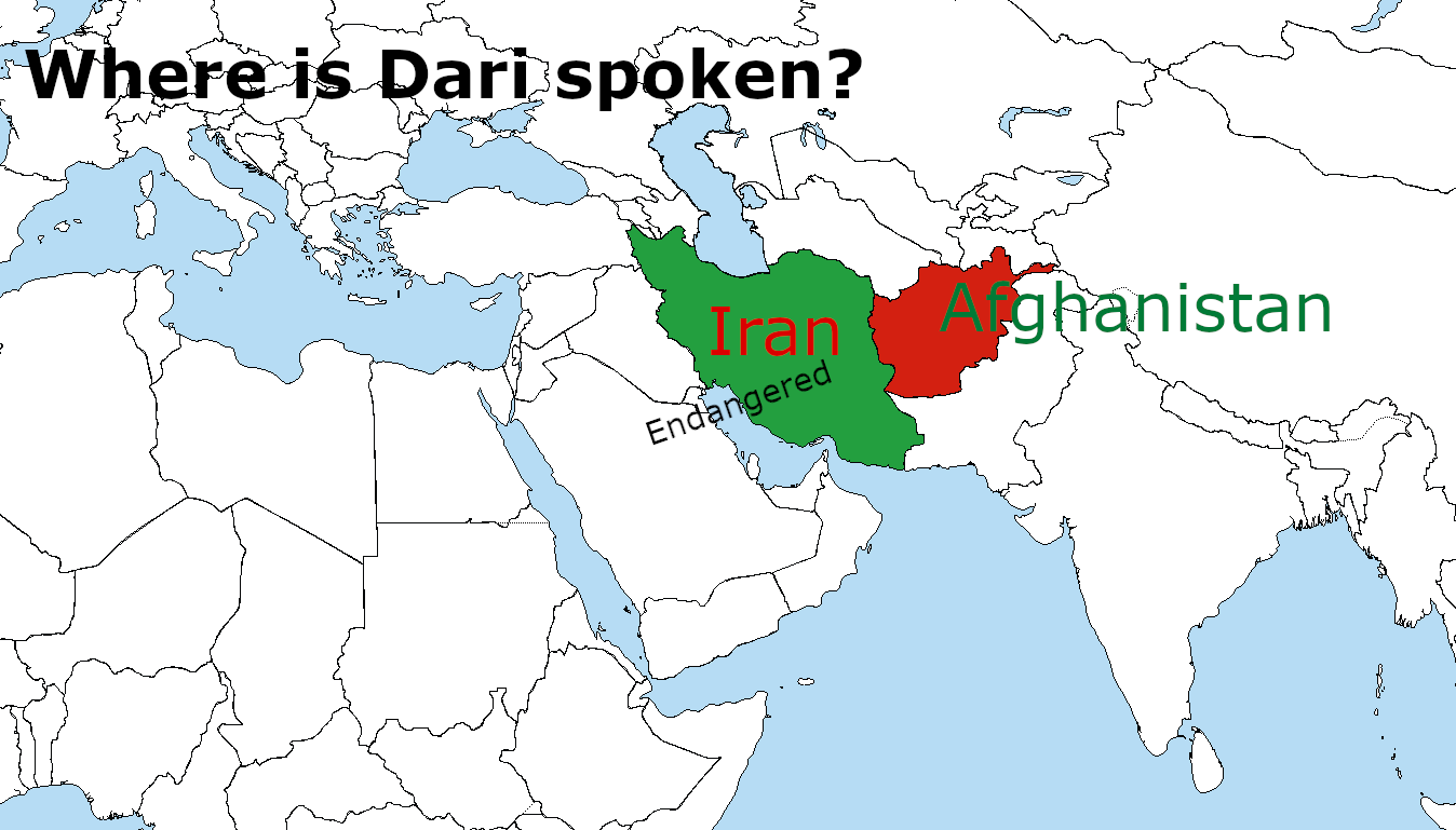
Derivative works of this file: Where is Dari Spoken? WhereisDariSpoken_MantraLingua.png
Filhistorikk
Klikk på et tidspunkt for å vise filen slik den var på det tidspunktet.
| Dato/klokkeslett | Miniatyrbilde | Dimensjoner | Bruker | Kommentar | |
|---|---|---|---|---|---|
| nåværende | 3. jun. 2023 kl. 20:40 | | 4 500 × 2 592 (233 KB) | DownwardSpiral1000 | The U.N. shows Donbass and Crimea as part of Ukraine, stop editing the map |
| 19. mai 2023 kl. 21:34 |  | 4 500 × 2 583 (189 KB) | Yann | Reverted to version as of 16:49, 17 May 2023 (UTC) | |
| 19. mai 2023 kl. 03:41 |  | 4 500 × 2 592 (233 KB) | PedroDuqueSantiago | Reverted to version as of 15:48, 14 May 2023 (UTC) | |
| 17. mai 2023 kl. 18:49 |  | 4 500 × 2 583 (189 KB) | JhonGame1 | Reverted to version as of 06:06, 13 May 2023 (UTC) | |
| 14. mai 2023 kl. 17:48 |  | 4 500 × 2 592 (233 KB) | Eurohunter | Reverted to version as of 11:53, 13 April 2023 (UTC) incorrect | |
| 13. mai 2023 kl. 08:06 |  | 4 500 × 2 583 (189 KB) | JhonGame1 | kosovo | |
| 12. mai 2023 kl. 18:08 |  | 4 500 × 2 583 (189 KB) | JhonGame1 | new borders | |
| 13. apr. 2023 kl. 13:53 |  | 4 500 × 2 592 (233 KB) | MixoMiso27 | Reverted to version as of 10:11, 30 March 2014 (UTC) | |
| 11. apr. 2023 kl. 00:16 |  | 4 500 × 2 583 (300 KB) | Forelie | Reverted to version as of 19:53, 23 March 2018 (UTC) | |
| 6. jun. 2018 kl. 19:52 |  | 4 500 × 2 592 (280 KB) | Cbrittain10 | Reverted to last version derived from the SVG. Please make corrections to the vector file before replacing the derived PNG. |
Filbruk
Det er ingen sider som bruker denne filen.
Global filbruk
Følgende andre wikier bruker denne filen:
- Bruk i en.wikipedia.org
- Bruk i it.wikibooks.org
- Bruk i pt.wikipedia.org