
Fil:Abbasid Caliphate 891-892.png

Størrelse på denne forhåndsvisningen: 800 × 382 piksler. Andre oppløsninger: 320 × 153 piksler | 640 × 306 piksler | 1 024 × 490 piksler | 1 280 × 612 piksler | 3 054 × 1 460 piksler.
Opprinnelig fil (3 054 × 1 460 piksler, filstørrelse: 1,44 MB, MIME-type: image/png)
| Denne filen er fra Wikimedia Commons og kan brukes av andre prosjekter. Informasjonen fra filbeskrivelsessiden vises nedenfor. |
Beskrivelse
| Beskrivelse |
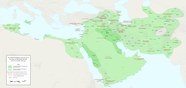
English: Map of the Abbasid Caliphate at the end of the reign of al-Mu'tamid in 891-892. Dark green denotes provinces under the effective control of the central government; light green denotes provinces under the control of autonomous governors or rebels.
The core Abbasid territories include Shahrazur, Darabadh, al-Samaghan, Hulwan, Masabadhan, Mihrijanqadhaq, the Euphrates districts, and Qarqisiyya (al-Tabari v. 37, p. 98; Bianquis p. 96). Map originally created as an .SVG file in Inkscape and converted to .PNG for size reasons. Background topography taken from DEMIS Mapserver, which are public domain. Works Cited:
|
| Dato | |
| Kilde | Eget verk |
| Opphavsperson | Ro4444 |
| Andre versjoner |
 |
Lisensiering
Jeg, rettighetsinnehaver av dette arbeidet, publiserer det herved under følgende lisens:
Denne filen er lisensiert under lisensen Creative Commons Navngivelse-DelPåSammeVilkår 4.0 Internasjonal.
- Du står fritt:
- til å dele – til å kopiere, distribuere og overføre verket
- til å blande – til å endre verket
- Under de følgende betingelsene:
- navngivelse – Du må kreditere verket på passende vis, lenke til lisensen og indikere hvorvidt det har blitt gjort endringer. Du kan gjøre det på enhver rimelig måte, men ikke på en måte som antyder at lisensgiveren støtter deg eller din bruk av verket.
- del på samme vilkår – Dersom du remikser, omarbeider eller på annen måte bygger på dette verket, må du kun distribuere resultatet under den samme eller en samsvarende lisens som denne.
Filhistorikk
Klikk på et tidspunkt for å vise filen slik den var på det tidspunktet.
| Dato/klokkeslett | Miniatyrbilde | Dimensjoner | Bruker | Kommentar | |
|---|---|---|---|---|---|
| nåværende | 4. des. 2017 kl. 01:18 | | 3 054 × 1 460 (1,44 MB) | Ro4444 | Further color corrections |
| 4. des. 2017 kl. 00:50 |  | 3 054 × 1 460 (1,44 MB) | Ro4444 | Color correction | |
| 3. des. 2017 kl. 23:11 |  | 3 054 × 1 460 (1,44 MB) | Ro4444 | User created page with UploadWizard |
Filbruk
Den følgende siden bruker denne filen:
Global filbruk
Følgende andre wikier bruker denne filen:
- Bruk i ar.wikipedia.org
- Bruk i de.wikiversity.org
- Bruk i en.wikipedia.org
- Bruk i en.wikibooks.org
- Bruk i et.wikipedia.org
- Bruk i fa.wikipedia.org
- Bruk i hy.wikipedia.org
- Bruk i id.wikipedia.org
- Bruk i ja.wikipedia.org
- Bruk i pt.wikipedia.org
- Bruk i sco.wikipedia.org
- Bruk i uk.wikipedia.org
- Bruk i uz.wikipedia.org
- Bruk i zh.wikipedia.org