
Fil:Positions of ancient continents, 550 million years ago.jpg
Størrelse på denne forhåndsvisningen: 600 × 600 piksler. Andre oppløsninger: 240 × 240 piksler | 480 × 480 piksler | 820 × 820 piksler.
Opprinnelig fil (820 × 820 piksler, filstørrelse: 426 KB, MIME-type: image/jpeg)
| Denne filen er fra Wikimedia Commons og kan brukes av andre prosjekter. Informasjonen fra filbeskrivelsessiden vises nedenfor. |

|
Dette bildet bør gjenskapes med hjelp av vektorgrafikk som en SVG-fil. Dette har flere fordeler, se Commons:Media for cleanup for mer informasjon. Hvis en SVG-fil med dette bildet er tilgjengelig, vennligst last den opp. Etter opplasting erstatt denne malen med {{vector version available|nytt bilde.svg}}.
|


|
This map has been uploaded by Electionworld from en.wikipedia.org to enable the |
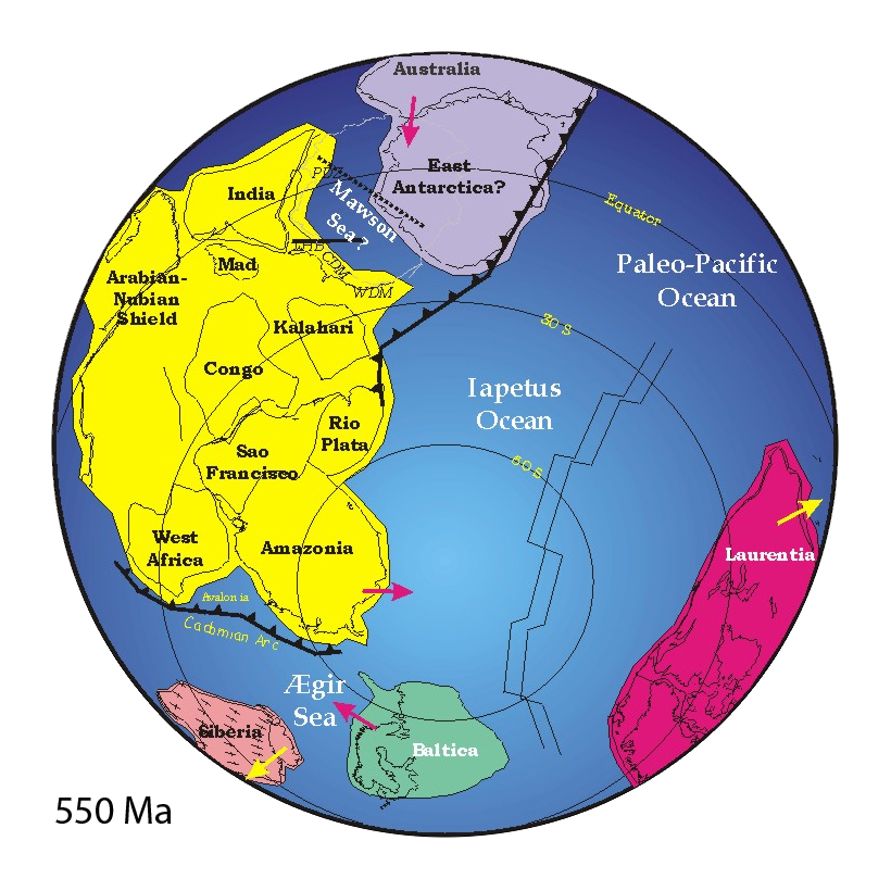
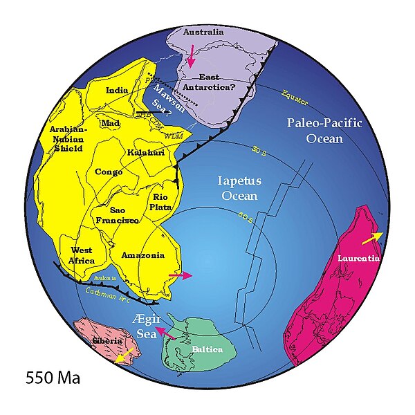
("Mad" = "Madagascar")
Beskrivelse
http://www.clas.ufl.edu/users/jmeert/550.jpg
Lisensiering
| Jeg, opphavsrettensholderen til dette verket, frigir dette verket til allmennheten. Dette gjelder på verdensbasis. I enkelte land kan dette være juridisk umulig. I så fall: Jeg gir hvem som helst retten til å bruke dette verket for ethvert formål, uten noen vilkår, med mindre slike vilkår kreves ved lov. |
Filhistorikk
Klikk på et tidspunkt for å vise filen slik den var på det tidspunktet.
| Dato/klokkeslett | Miniatyrbilde | Dimensjoner | Bruker | Kommentar | |
|---|---|---|---|---|---|
| nåværende | 25. mai 2007 kl. 17:44 | | 820 × 820 (426 KB) | Wiggum | |
| 3. des. 2006 kl. 21:27 |  | 800 × 889 (160 KB) | Electionworld | {{ew|en|Jmeert}} == Summary == http://www.clas.ufl.edu/users/jmeert/550.jpg == Licensing == {{PD-self}} |
Filbruk
De følgende 8 sidene bruker denne filen:
Global filbruk
Følgende andre wikier bruker denne filen:
- Bruk i af.wikipedia.org
- Bruk i ar.wikipedia.org
- Bruk i bat-smg.wikipedia.org
- Bruk i bg.wikipedia.org
- Bruk i bs.wikipedia.org
- Bruk i ca.wikipedia.org
- Bruk i cs.wikipedia.org
- Bruk i cv.wikipedia.org
- Bruk i cy.wikipedia.org
- Bruk i da.wikipedia.org
- Bruk i de.wikipedia.org
- Superkontinent
- Uluru
- Iapetus (Ozean)
- Ediacarium
- Rodinia
- Pannotia
- Proto-Tethys
- Comley Series
- Ostgondwana
- Yamato-Belgica-Komplex
- Geologie Ostantarktikas
- Westgondwana
- Geologie Spitzbergens
- Geologie der Ostghats
- Shillong-Plateau
- Tektonische Entwicklung des indischen Subkontinents
- Geologie des Niedrigen Himalayas
- Zerfall Gondwanas
- Bruk i en.wikipedia.org
Vis mer global bruk av denne filen.